
Reference overview
Beyşehir Tarih ve Kültür Mirası
Beyşehir Belediyesi · Beyşehir Belediyesi
Read the place guides and stories that draw on this source.
Read with your device’s voice.
From Erbaba to Eşrefoğlu
From Neolithic settlement to Hittite monuments and the medieval town.
The Beyşehir basin’s history begins long before its standing medieval monuments. Erbaba Höyük belongs to the region’s prehistoric settlement story. Considering it alongside mosque, bridge and lakeside town changes the timescale of a visit: people lived in this landscape long before the buildings that now dominate an architectural tour.
A höyük is a mound formed through accumulated occupation and rebuilding, not a single intact building. Archaeological interpretation draws on excavation contexts and the relationship between layers. A visitor looking at a rise in the landscape cannot reproduce that investigation simply by imagining houses upon it.
The district history identifies Erbaba among early settlements. Detailed claims about individual houses or entry from rooftops require excavation publications. Similarity to another Anatolian site is a question to investigate, not permission to import a familiar reconstruction from Çatalhöyük. The same applies to the surroundings: modern fields and shoreline are not a frozen image of the prehistoric environment.
Use Erbaba as a reason to read the basin across several periods. The regional photograph provides context, not a reconstruction or an image of the excavation itself. Establish access separately, avoid walking on protected remains and never collect material. Distinguishing excavated evidence from a suggested interpretation allows the earliest chapter of the region’s story to retain its own questions, rather than becoming a decorative preface to the medieval town.
Reading a mound requires a different pace from visiting a standing monument. There may be no complete facade to photograph and no single room to enter. The interest lies in how archaeological investigation turns relationships between deposits, objects and construction traces into an account of repeated occupation.
Think about the difference between the landscape you can see and a past environment reconstructed through research. A modern shoreline, field boundary or road is a present reference point. It helps locate a visit, but does not automatically explain how the same ground was used in prehistory.
Place Erbaba on a timeline with the Hittite monuments and Eşrefoğlu Mosque. The spaces between those chapters matter as much as the labels. They prevent the region's history from appearing as a smooth procession of buildings and remind you that many forms of life leave less immediately visible remains.
Heritage layers provides that longer view, while Lake life returns to the basin's changing edges. Use them to plan a reading journey even if a site visit is not possible. The value of the prehistoric chapter lies in changing the questions you ask about the region, not simply adding another pin.
Check current access and visiting arrangements locally.
Bedesten
A pause beneath the domes at the heart of the old town.
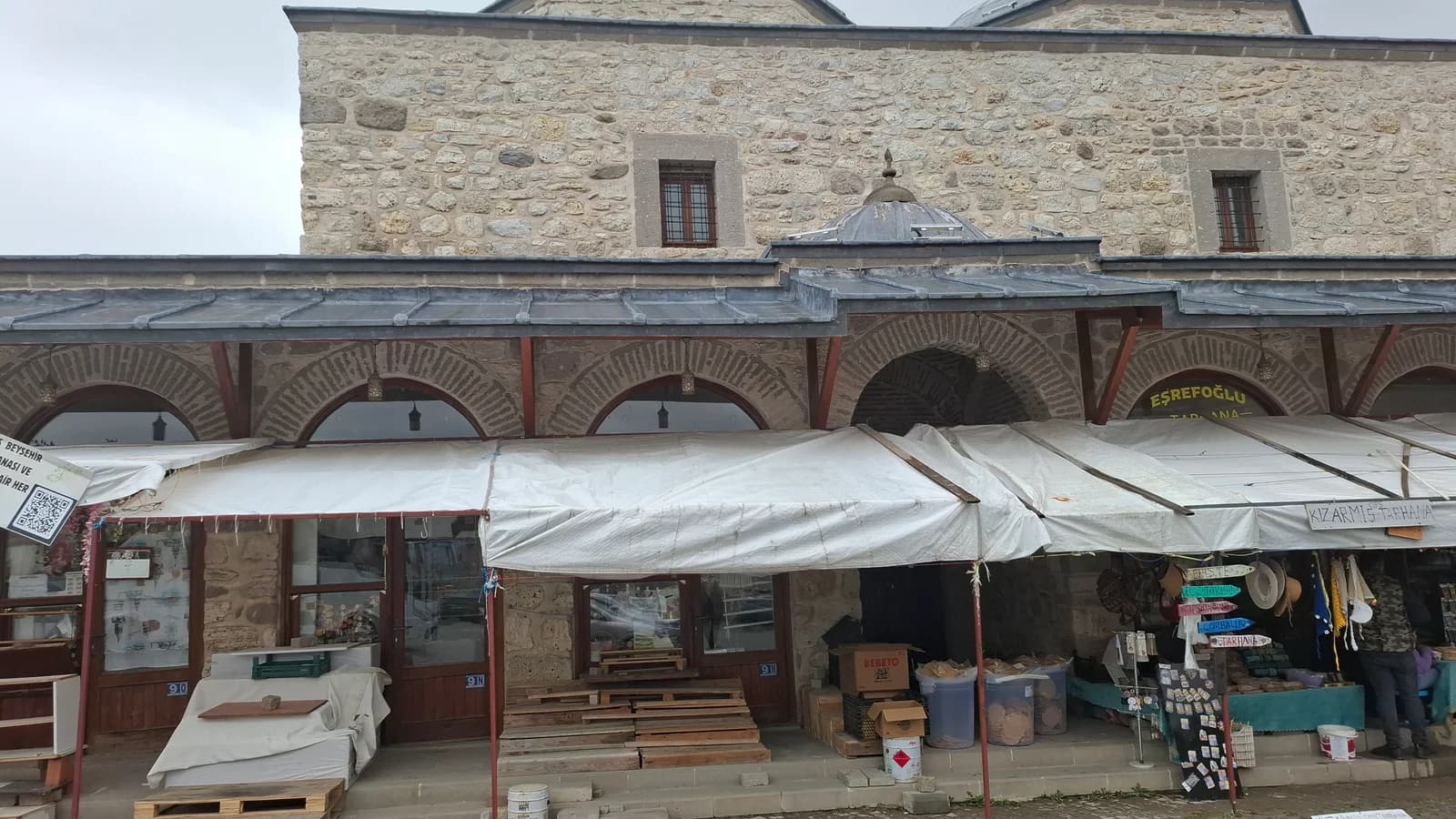
Beyşehir’s Bedesten is a useful place to think about the town as a network of everyday activities. A covered market is more than a picturesque building beside a famous mosque. Its entrances, sheltered interior and domed roof belong to the organisation of exchange: people arriving, goods changing hands and routes through the neighbourhood meeting at a recognisable place.
The municipal heritage accounts describe the building and its repairs. Read the market as a structure shaped by successive uses and interventions. Its construction date is disputed across the sources, while its form and place in the neighbourhood offer a clear starting point for a visit. Look at the roof, entrances and surrounding streets to understand how a sheltered trading space meets the town outside.
Look at the repeated bays and the relationship between roof and walls. Then consider the entrances from the street: where does an approach become a threshold, and how does the covered space change movement? Follow those changes at walking pace, moving from the exposed street into the sheltered threshold. The neighbouring mosque and bathhouse extend the story through their own histories of worship, trade and daily life.
Complete the visit by walking between the market and the neighbouring streets. The contrast between a sheltered trading space and the open street makes the building’s purpose easier to imagine. Look back towards the mosque: commerce, worship and domestic life occupied the same compact urban landscape. Ask before photographing someone at work, and take time to notice the smaller doorways and thresholds between the better-known monuments.
A covered market can be read through a simple sequence: approach, entrance, interior and return to the street. Notice where the roof first changes the light, how one opening frames another, and whether the building encourages a direct passage or a pause. Those spatial clues remain useful even when a historic trading function has changed.
Look at the domed units as a repeated arrangement rather than as one continuous roof. Each bay contributes to a larger whole, much as individual shopfronts form the rhythm of a street. Compare the sheltered volume with the mosque's columned hall; both use repetition, but they organise different activities and different kinds of gathering.
The nearby bathhouse broadens this reading from exchange to daily routines. Its more enclosed exterior creates a different threshold from the market entrance. Walking between the two makes it possible to compare building types without assuming that the same people used them in precisely the same way through every period.
Continue with Beyşehir's table for food and preparation, or Artisans of Huğlu and Üzümlü for work beyond the town centre. These connections give the market story a human scale. If someone shares a memory of the building, note the speaker and occasion; a personal recollection adds a distinct voice alongside the architectural evidence.
Castle Gate
A gate and surviving walls recall the scale of the older town.
İçerişehir’s gate marks a change of pace between the wider town and its historic streets. Pause before walking through and look at the opening as part of a wall, rather than as an isolated architectural fragment. The passage gives shape to arrival: it narrows the view, then opens it again towards the neighbourhood beyond.
The municipal heritage account places the gate within Beyşehir’s fortified past. Today it helps orient a walk between the old town’s monuments. Its value lies partly in this relationship with the surrounding streets, where religious buildings, trading spaces and smaller thresholds form a closely connected setting.
Compare the gate’s large opening with the entrances encountered as you continue towards the mosque and market. Differences in scale suggest different purposes: entry into a neighbourhood, entry into a place of worship, entry into a shop or house. Looking back after passing through gives a second view of the same structure and makes its relationship with the street clearer.
A gateway gives a street a before and after. Look through the opening before passing it, then look back from the other side. The same masonry frames different parts of the neighbourhood in each direction. This makes the gate useful for understanding arrival rather than simply collecting a photograph of a historic facade.
Notice the difference between the opening's depth and the width of the street beyond. A passage can compress the view, drawing attention to the space that follows. Keep the actual pedestrian movement in mind while stopping; a threshold that interests visitors may also remain part of someone's ordinary route.
The gate also introduces a comparison of materials. Rougher wall surfaces, more carefully worked edges and later repairs can have different appearances. Describe the visible contrast without assigning every stone to a precise date. A close photograph and a wider street view preserve different parts of the same observation.
Continue towards the mosque and compare another kind of entrance. Eşrefoğlu's portal belongs to a place of worship, while the gateway shapes an approach to the neighbourhood. The scale and decoration ask different things of the person arriving. Seeing them together makes the meaning of a threshold more specific.
Market memory extends this comparison to the covered trading space. Travelers' accounts invites you to imagine how arrival was described by earlier visitors, using their words carefully beside the present street. Finish by taking the old-town walk at a pace that leaves time for the smaller entrances between the main monuments.
Eşrefoğlu Bathhouse
Another layer of historic daily life near the Bedesten.
A bathhouse adds everyday life to a walk often remembered for its monumental mosque. Eşrefoğlu Hamamı belongs to the historic neighbourhood’s network of buildings serving different needs. Seen beside the places of worship and exchange, it helps explain the old town as a setting for daily routines as well as ceremonial occasions.
Start with the building’s exterior and its position in the street. A bathhouse organises movement between spaces with different functions, while its enclosed form presents a different relationship with daylight from an open market entrance or mosque portal. The municipal account provides the historical reference for this stop.
Continue the comparison outside: consider the distance to the mosque and market, and how a person might encounter several kinds of building in one short walk. Present access and use need to be checked locally. Even an exterior visit can add another layer to the neighbourhood’s story, shifting attention from the exceptional monument to the practical architecture surrounding it.
The bathhouse invites attention to buildings that supported everyday life around the more famous mosque. Its significance is partly relational: how close it stands to other uses, how its exterior meets the street and what kind of entrance it presents. These questions can be explored even when only an exterior visit is possible.
Compare an enclosed wall with an open market entrance. They organise light, privacy and movement differently. Avoid treating every historic building as a hall designed to be seen at once. Some kinds of architecture are understood through a sequence of spaces, and an outside view only begins that account.
The term külliye helps introduce a broader network of functions, but nearby buildings still need their own histories. Read the bathhouse's source alongside the mosque account rather than automatically assigning the same date or patron to every neighbour. Physical proximity is the beginning of a question, not its complete answer.
From a public place, include a section of the surrounding street in a photograph. The image will show how the building belongs to the neighbourhood rather than presenting it as an isolated museum object. Leave residents and current users room to enter and pass as you look.
Market memory and Beyşehir's table develop other forms of everyday activity, while A world held by wood returns to the monumental interior nearby. Reading these subjects together gives the old town a fuller character: worship, exchange, preparation and personal routines occupying a shared urban setting.
Fasıllar Monument
The rock monument also known as Kurt Beşiği.
At Fasıllar, scale is impossible to ignore. An image worked into one substantial stone raises questions about planning, carving and placement. These are the starting points for a visit, rather than questions that a dramatic caption can settle. The relationship between the object and the ground is as important as an isolated view of a carved figure.
Municipal accounts place the monument within Hittite heritage. Its visual language connects it with a wider tradition, while it remains a particular object in a particular setting. Begin with the whole form before separating elements of its composition. A comparison with Eflatunpınar reveals differences between a monolith and a structure assembled from blocks beside water.
Accounts sometimes propose a connection with another site or an intended transport. Those proposals are interpretations, not eyewitness records of a failed operation. The reason an object stayed in one place, its proposed destination and its original function need specific evidence. Size alone does not supply all those answers.
Leave time to study the surrounding setting without climbing the monument. Nearby classical heritage belongs to another historical chapter and needs separate labels. Contextual images from other sites are named accordingly, never presented as photographs of this object. A good regional journey is a sequence of distinct places with published evidence and open questions, rather than a blur of ancient dates and borrowed descriptions.
From a suitable viewing position, let the stone's outline guide your first look. Separate the outer mass from the carved composition and then bring them back together. This makes it easier to see how the image occupies the available surface rather than imagining the relief as an independent object.
Compare a wide photograph with a detail taken from the same permitted area. The wide view preserves scale and terrain; the detail makes an individual contour easier to study. Keep both, because an impressive close-up can otherwise erase the physical relationship that first caught your attention.
The comparison with Eflatunpınar is most useful when it begins with things you can identify: one large stone, multiple joined blocks, a hillside setting and a spring pool. These observations provide a clear foundation for reading specialist interpretations without confusing an attractive proposal with an established construction sequence.
Ares and Lukyanos introduces a different historical layer in the wider district. Reading stone brings the regional comparisons together, while Heritage layers supplies a longer chronology. Allow those connections to widen the visit, but give each monument its own caption, evidence and place in your notes.
Kubadabad Palace
A connection between palace remains and tiles now in museums.
Kubad-Abad can be approached through two very different scales. The lakeside remains invite you to think about a palace as an arrangement of spaces in a landscape. A tile asks for close attention to colour, outline and surface. Moving between those scales is the most rewarding way to read the site: the building explains where decorated surfaces belonged, while the surviving objects give presence to rooms that can no longer be seen complete.
The municipal heritage account associates the palace with Alaaddin Keykubad I and places the complex beside Lake Beyşehir at the foot of the Anamas mountains. Begin with that setting before trying to reconstruct a royal interior. Water, slope and distant skyline belong to the architectural story. The palace was located in a particular environment, not on an empty background that can be removed from the account.
Kâmil Uğurlu's architectural account describes an excavated complex containing two principal palatial buildings, a lakeside boathouse and service buildings. That changes the picture from one isolated royal hall to an organised lakeside site. From permitted viewpoints, consider how surviving walls mark spaces within that larger arrangement. Palace life required movement, storage and support as well as decorated rooms.
The same account traces the identification of the ruins to M. Zeki Oral's work with written sources and records excavation campaigns under Katharina Otto-Dorn in the 1960s and Rüçhan Arık from 1980. This is part of the place's modern history: the palace has also been reconstructed as knowledge, through texts, excavation and the comparison of fragments.
Karatay's tiles, documented by Museum With No Frontiers, make the design easier to recognise. Eight-pointed stars were combined with cross-shaped pieces to form larger panels. In the underglaze examples, black, turquoise and dark blue decoration appears beneath a transparent glaze. Look first at this relationship between outline and colour; the shapes are part of a joined surface, not simply independent pictures.
The same collection account describes human and animal figures, including fantastic creatures and double-headed eagles. Stars frequently carry figures, while connecting pieces often carry vegetal decoration. Follow how the designer fills a star's points and centre. The distinction between a single figure and a repeated wall arrangement gives the tiles both an intimate scale and an architectural one.
Colour adds another layer. Glazed surfaces respond differently to lighting, photography and museum display, so reproductions do not always make the same object look identical. Compare the pattern and outline as well as the apparent hue. The aim is to understand how decorated pieces contribute to an interior, rather than to use a single screen image as an exact reference for the original colour of an entire palace.
Seeing material in a museum is a separate part of the journey. The municipality points readers towards collections in Konya, including Karatay, for excavated tiles. Check current display arrangements with the relevant museum before travelling for a particular object. The lake site offers the relationship between building and landscape; a collection allows a closer encounter with surviving objects and their documentation.
Back in Beyşehir, Eşrefoğlu Mosque offers a useful comparison in how materials guide attention. Timber columns organise a large space; fittings and decorated surfaces focus a closer look. These places differ in patronage, function and survival, and should not be collapsed into a single generic 'Seljuk interior'. Comparing them is valuable precisely because each asks you to move between architectural scale and individual workmanship.
Island communities offers another lake connection through surviving structures and the relationship between land and water. Read it after the palace account to widen the frame beyond a single site. The comparison concerns landscape and ways of interpreting remains; it is not a claim that every island building belonged to one palace complex or can be assigned to the same period.
Plan Kubad-Abad as a regional visit with its own access arrangements, not as a short extension of the old-town walking route. Check whether the archaeological site is accessible and which areas may be visited. Stay within permitted paths, leave loose material in place and allow time for the outward and return journey. A concise visit to an accessible viewpoint is preferable to assuming that every visible ruin is open for exploration.
Afterwards, organise your photographs into three groups: landscape, surviving architecture and individual objects. Write down where each image was made, especially when a museum visit forms part of the same trip. Read Palace tiles alongside Lake life and the mosque's Mihrab and minbar story. Together they make material, setting and present-day experience part of one connected journey without blurring the identity of the places.
The memory of the market
The Bedesten and its relationship with nearby streets.
Beyşehir’s Bedesten is a useful place to think about the town as a network of everyday activities. A covered market is more than a picturesque building beside a famous mosque. Its entrances, sheltered interior and domed roof belong to the organisation of exchange: people arriving, goods changing hands and routes through the neighbourhood meeting at a recognisable place.
The municipal heritage accounts describe the building and its repairs. Read the market as a structure shaped by successive uses and interventions. Its construction date is disputed across the sources, while its form and place in the neighbourhood offer a clear starting point for a visit. Look at the roof, entrances and surrounding streets to understand how a sheltered trading space meets the town outside.
Look at the repeated bays and the relationship between roof and walls. Then consider the entrances from the street: where does an approach become a threshold, and how does the covered space change movement? Follow those changes at walking pace, moving from the exposed street into the sheltered threshold. The neighbouring mosque and bathhouse extend the story through their own histories of worship, trade and daily life.
Complete the visit by walking between the market and the neighbouring streets. The contrast between a sheltered trading space and the open street makes the building’s purpose easier to imagine. Look back towards the mosque: commerce, worship and domestic life occupied the same compact urban landscape. Ask before photographing someone at work, and take time to notice the smaller doorways and thresholds between the better-known monuments.
A covered market can be read through a simple sequence: approach, entrance, interior and return to the street. Notice where the roof first changes the light, how one opening frames another, and whether the building encourages a direct passage or a pause. Those spatial clues remain useful even when a historic trading function has changed.
Look at the domed units as a repeated arrangement rather than as one continuous roof. Each bay contributes to a larger whole, much as individual shopfronts form the rhythm of a street. Compare the sheltered volume with the mosque's columned hall; both use repetition, but they organise different activities and different kinds of gathering.
The nearby bathhouse broadens this reading from exchange to daily routines. Its more enclosed exterior creates a different threshold from the market entrance. Walking between the two makes it possible to compare building types without assuming that the same people used them in precisely the same way through every period.
Continue with Beyşehir's table for food and preparation, or Artisans of Huğlu and Üzümlü for work beyond the town centre. These connections give the market story a human scale. If someone shares a memory of the building, note the speaker and occasion; a personal recollection adds a distinct voice alongside the architectural evidence.
Traces of a palace in tile
A story connecting Kubadabad to museum galleries.
Kubad-Abad can be approached through two very different scales. The lakeside remains invite you to think about a palace as an arrangement of spaces in a landscape. A tile asks for close attention to colour, outline and surface. Moving between those scales is the most rewarding way to read the site: the building explains where decorated surfaces belonged, while the surviving objects give presence to rooms that can no longer be seen complete.
The municipal heritage account associates the palace with Alaaddin Keykubad I and places the complex beside Lake Beyşehir at the foot of the Anamas mountains. Begin with that setting before trying to reconstruct a royal interior. Water, slope and distant skyline belong to the architectural story. The palace was located in a particular environment, not on an empty background that can be removed from the account.
Kâmil Uğurlu's architectural account describes an excavated complex containing two principal palatial buildings, a lakeside boathouse and service buildings. That changes the picture from one isolated royal hall to an organised lakeside site. From permitted viewpoints, consider how surviving walls mark spaces within that larger arrangement. Palace life required movement, storage and support as well as decorated rooms.
The same account traces the identification of the ruins to M. Zeki Oral's work with written sources and records excavation campaigns under Katharina Otto-Dorn in the 1960s and Rüçhan Arık from 1980. This is part of the place's modern history: the palace has also been reconstructed as knowledge, through texts, excavation and the comparison of fragments.
Karatay's tiles, documented by Museum With No Frontiers, make the design easier to recognise. Eight-pointed stars were combined with cross-shaped pieces to form larger panels. In the underglaze examples, black, turquoise and dark blue decoration appears beneath a transparent glaze. Look first at this relationship between outline and colour; the shapes are part of a joined surface, not simply independent pictures.
The same collection account describes human and animal figures, including fantastic creatures and double-headed eagles. Stars frequently carry figures, while connecting pieces often carry vegetal decoration. Follow how the designer fills a star's points and centre. The distinction between a single figure and a repeated wall arrangement gives the tiles both an intimate scale and an architectural one.
Colour adds another layer. Glazed surfaces respond differently to lighting, photography and museum display, so reproductions do not always make the same object look identical. Compare the pattern and outline as well as the apparent hue. The aim is to understand how decorated pieces contribute to an interior, rather than to use a single screen image as an exact reference for the original colour of an entire palace.
Seeing material in a museum is a separate part of the journey. The municipality points readers towards collections in Konya, including Karatay, for excavated tiles. Check current display arrangements with the relevant museum before travelling for a particular object. The lake site offers the relationship between building and landscape; a collection allows a closer encounter with surviving objects and their documentation.
Back in Beyşehir, Eşrefoğlu Mosque offers a useful comparison in how materials guide attention. Timber columns organise a large space; fittings and decorated surfaces focus a closer look. These places differ in patronage, function and survival, and should not be collapsed into a single generic 'Seljuk interior'. Comparing them is valuable precisely because each asks you to move between architectural scale and individual workmanship.
Island communities offers another lake connection through surviving structures and the relationship between land and water. Read it after the palace account to widen the frame beyond a single site. The comparison concerns landscape and ways of interpreting remains; it is not a claim that every island building belonged to one palace complex or can be assigned to the same period.
Plan Kubad-Abad as a regional visit with its own access arrangements, not as a short extension of the old-town walking route. Check whether the archaeological site is accessible and which areas may be visited. Stay within permitted paths, leave loose material in place and allow time for the outward and return journey. A concise visit to an accessible viewpoint is preferable to assuming that every visible ruin is open for exploration.
Afterwards, organise your photographs into three groups: landscape, surviving architecture and individual objects. Write down where each image was made, especially when a museum visit forms part of the same trip. Read Palace tiles alongside Lake life and the mosque's Mihrab and minbar story. Together they make material, setting and present-day experience part of one connected journey without blurring the identity of the places.
Reading stone
Scale, water and imagery at Eflatunpınar and Fasıllar.
Eflatunpınar and Fasıllar offer two different encounters with Hittite stonework around Beyşehir. At one, an arrangement of carved blocks belongs to a spring and pool; at the other, a large monolithic carving makes its material and scale immediately apparent. The sites are rewarding to compare because they are different. Treating them as two interchangeable ancient photo stops would miss the questions each one opens.
Eflatunpınar is identified in the municipal heritage account as a Hittite spring monument of the late thirteenth century BCE. Its carved facade stands with a pool, placing water at the centre of the encounter. Begin with that whole arrangement before following individual figures. The setting belongs to an ancient built treatment of a spring, rather than a sculpture subsequently placed beside an attractive pond.
Next, follow the seams between the blocks. Some lines belong to the assembly of the structure; others form part of the carving. Separating those two kinds of line helps the composition become clearer. It also introduces the practical side of making a monument: a large image assembled from pieces requires choices about alignment and the way individual stones contribute to the whole.
Move your attention between a broad view and one detail you can recognise. A weathered outline may look different with a change of light, and a published drawing may identify a form that is difficult to distinguish on site. Use that difference as a reason to look carefully. There is no need to turn every uncertain contour into a confidently named figure in order to appreciate the workmanship.
At Fasıllar, the municipality describes a monumental stone carved with two divine figures arranged one above the other and lions beside the lower figure. Begin with that composition within the whole mass. Its place on the slope makes the relationship between carving and terrain especially apparent, while a tightly cropped image can conceal the scale of the stone.
The word monolith draws attention to that single-stone character. Compare it with the joined blocks at Eflatunpınar and consider the different practical questions each form raises. How does the available surface influence a composition, and how does a viewer read an image distributed across pieces? These questions give a visit direction without requiring an invented reconstruction of tools, labour or an undocumented workday.
Interpretations have proposed relationships between the two monuments, including possible intended placement. Such proposals belong to the history of research and should retain that status. They can be interesting to investigate without becoming an eyewitness story of a stone being abandoned during transport. The surviving objects allow comparison; they do not, on their own, disclose every decision behind their creation.
The wider Fasıllar landscape also contains heritage associated with other periods. The Lukyanos inscription introduces a different kind of object: words on stone, rather than the visual composition of the Hittite monument. Read Ares and Lukyanos for that change of focus, and keep locations, dates and source accounts distinct. Geographical proximity does not make every carved surface part of a single historical episode.
A useful way to organise your photographs is to pair context and detail at each place. First record the monument in its setting from an authorised position; then record a visible feature without approaching protected surfaces. Add the place name to your notes immediately. Two days later, small stone details can be surprisingly easy to confuse when their background has disappeared from the frame.
Plan these sites as regional visits requiring transport and current access information. They are not consecutive stops on a verified pedestrian trail from the old town. Leave enough time to read the setting at each place rather than using the journey only to collect two pictures. Weather and daylight affect what you can see, but no particular lighting condition justifies climbing a monument or entering a restricted area.
On site, keep to permitted areas and leave the stone untouched. Do not wet a surface to make a carving appear clearer, trace it by rubbing or collect material from the ground. A patient look, a photograph taken from a suitable position and a comparison with published documentation offer a fuller experience without altering what the next visitor will find.
Continue with Hittite water cult for a closer reading of Eflatunpınar, Fasıllar monolith for the single-stone monument, and Heritage layers for a longer chronology of the basin. Water and city provides a much later comparison in how building responds to water. Read that as a shared question across very different periods, rather than evidence of an unbroken purpose or one civilisation's direct continuation into another.
Erbaba Höyük & Neolithic Stone Architecture
Contiguous stone-founded Neolithic houses uncovered through the excavations of Jacques and Louise Bordaz.
The Beyşehir basin’s history begins long before its standing medieval monuments. Erbaba Höyük belongs to the region’s prehistoric settlement story. Considering it alongside mosque, bridge and lakeside town changes the timescale of a visit: people lived in this landscape long before the buildings that now dominate an architectural tour.
A höyük is a mound formed through accumulated occupation and rebuilding, not a single intact building. Archaeological interpretation draws on excavation contexts and the relationship between layers. A visitor looking at a rise in the landscape cannot reproduce that investigation simply by imagining houses upon it.
The district history identifies Erbaba among early settlements. Detailed claims about individual houses or entry from rooftops require excavation publications. Similarity to another Anatolian site is a question to investigate, not permission to import a familiar reconstruction from Çatalhöyük. The same applies to the surroundings: modern fields and shoreline are not a frozen image of the prehistoric environment.
Use Erbaba as a reason to read the basin across several periods. The regional photograph provides context, not a reconstruction or an image of the excavation itself. Establish access separately, avoid walking on protected remains and never collect material. Distinguishing excavated evidence from a suggested interpretation allows the earliest chapter of the region’s story to retain its own questions, rather than becoming a decorative preface to the medieval town.
Reading a mound requires a different pace from visiting a standing monument. There may be no complete facade to photograph and no single room to enter. The interest lies in how archaeological investigation turns relationships between deposits, objects and construction traces into an account of repeated occupation.
Think about the difference between the landscape you can see and a past environment reconstructed through research. A modern shoreline, field boundary or road is a present reference point. It helps locate a visit, but does not automatically explain how the same ground was used in prehistory.
Place Erbaba on a timeline with the Hittite monuments and Eşrefoğlu Mosque. The spaces between those chapters matter as much as the labels. They prevent the region's history from appearing as a smooth procession of buildings and remind you that many forms of life leave less immediately visible remains.
Heritage layers provides that longer view, while Lake life returns to the basin's changing edges. Use them to plan a reading journey even if a site visit is not possible. The value of the prehistoric chapter lies in changing the questions you ask about the region, not simply adding another pin.
Giant on the Slope: The Fasıllar Monolith
One of Anatolia’s largest monolithic sculptures, the 8-metre Kurtbeşiği monument.
At Fasıllar, scale is impossible to ignore. An image worked into one substantial stone raises questions about planning, carving and placement. These are the starting points for a visit, rather than questions that a dramatic caption can settle. The relationship between the object and the ground is as important as an isolated view of a carved figure.
Municipal accounts place the monument within Hittite heritage. Its visual language connects it with a wider tradition, while it remains a particular object in a particular setting. Begin with the whole form before separating elements of its composition. A comparison with Eflatunpınar reveals differences between a monolith and a structure assembled from blocks beside water.
Accounts sometimes propose a connection with another site or an intended transport. Those proposals are interpretations, not eyewitness records of a failed operation. The reason an object stayed in one place, its proposed destination and its original function need specific evidence. Size alone does not supply all those answers.
Leave time to study the surrounding setting without climbing the monument. Nearby classical heritage belongs to another historical chapter and needs separate labels. Contextual images from other sites are named accordingly, never presented as photographs of this object. A good regional journey is a sequence of distinct places with published evidence and open questions, rather than a blur of ancient dates and borrowed descriptions.
From a suitable viewing position, let the stone's outline guide your first look. Separate the outer mass from the carved composition and then bring them back together. This makes it easier to see how the image occupies the available surface rather than imagining the relief as an independent object.
Compare a wide photograph with a detail taken from the same permitted area. The wide view preserves scale and terrain; the detail makes an individual contour easier to study. Keep both, because an impressive close-up can otherwise erase the physical relationship that first caught your attention.
The comparison with Eflatunpınar is most useful when it begins with things you can identify: one large stone, multiple joined blocks, a hillside setting and a spring pool. These observations provide a clear foundation for reading specialist interpretations without confusing an attractive proposal with an established construction sequence.
Ares and Lukyanos introduces a different historical layer in the wider district. Reading stone brings the regional comparisons together, while Heritage layers supplies a longer chronology. Allow those connections to widen the visit, but give each monument its own caption, evidence and place in your notes.
Related places
- Eşrefoğlu Mosque
- Bedesten
- Lake Beyşehir
- Castle Gate
- Eşrefoğlu Bathhouse
- Eflatunpınar
- Fasıllar Monument
- Kubadabad Palace
·