
Reference overview
Derebucak Belediyesi Tarihçe
Derebucak Belediyesi · Derebucak Belediyesi
Read the place guides and stories that draw on this source.
Read with your device’s voice.
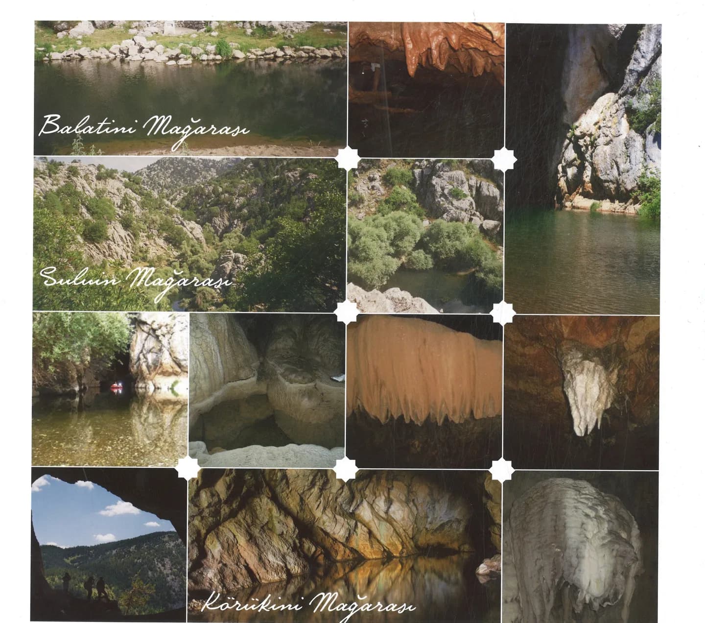
Balatini, Körükini and Suluin
An underground water landscape around Çamlık and Derebucak.
Around Derebucak and the western lake region, water moving through rock creates a landscape that extends below the surface. Valleys and forested slopes are only part of it. Underground passages, pools and flowing water involve conditions very different from an ordinary walk, and a dramatic entrance photograph rarely conveys that difference.
Municipal and provincial culture accounts describe Balatini, Körükini, Suluin and Pınargözü as distinct places. Their names should not become interchangeable labels for a generic cave image. Balatini’s entrance and interior photographs show the contrast between the landscape outside and the spaces formed within the limestone. Forested approaches help place the caves within the wider mountain scenery.
Water provides a common theme across these separate cave sites. Follow the published descriptions of each entrance, passage and watercourse, keeping the place names alongside your notes. The regional comparison explains how water shapes rock and movement. Each cave also has its own flow and access conditions, which need a separate plan for a visit with qualified guidance.
The distinction matters for visiting. A dry-looking entrance may lead to a water passage, and an approximate map pin is not a safe entry point. Plan the landscape visit first, then ask the responsible authority or qualified guides about any cave activity. Keep individual sites separate in notes and photographs. Understanding how water shapes the region does not require entering every cavity: the sources, entrance setting and surrounding terrain already offer a substantial account.
Read the outside landscape before concentrating on an entrance. A valley, exposed rock and vegetation can establish the scale of the setting better than a dark opening alone. A visit that stays outside can still introduce the relationship between rock and water, especially when compared with a clearly identified interior photograph.
Separate the purpose of each picture. An entrance view helps recognise a location, a regional forest view gives atmosphere, and an interior image records conditions at a particular point. None supplies the continuous information needed for moving through a cave. Their value increases when captions preserve those distinctions.
Keep Balatini, Körükini, Suluin and Pınargözü as separate entries in your notes. Compare what the official accounts say about each place rather than assuming the same equipment, access or flow conditions apply everywhere. Being part of the same wider karst landscape does not make sites interchangeable.
Continue with İslibucak forest for a surface landscape outing and Anamas and Karagöl for the mountain setting. Lake life offers a contrasting view of open water. These connections allow a full regional reading without making underground entry a required achievement or turning a speculative line between caves into a visitor route.
Do not enter without current access permission and professional guidance. Flooding and water passages can change.
Pınargözü Cave
An active water cave near Yenişarbademli.
Around Derebucak and the western lake region, water moving through rock creates a landscape that extends below the surface. Valleys and forested slopes are only part of it. Underground passages, pools and flowing water involve conditions very different from an ordinary walk, and a dramatic entrance photograph rarely conveys that difference.
Municipal and provincial culture accounts describe Balatini, Körükini, Suluin and Pınargözü as distinct places. Their names should not become interchangeable labels for a generic cave image. Balatini’s entrance and interior photographs show the contrast between the landscape outside and the spaces formed within the limestone. Forested approaches help place the caves within the wider mountain scenery.
Water provides a common theme across these separate cave sites. Follow the published descriptions of each entrance, passage and watercourse, keeping the place names alongside your notes. The regional comparison explains how water shapes rock and movement. Each cave also has its own flow and access conditions, which need a separate plan for a visit with qualified guidance.
The distinction matters for visiting. A dry-looking entrance may lead to a water passage, and an approximate map pin is not a safe entry point. Plan the landscape visit first, then ask the responsible authority or qualified guides about any cave activity. Keep individual sites separate in notes and photographs. Understanding how water shapes the region does not require entering every cavity: the sources, entrance setting and surrounding terrain already offer a substantial account.
Read the outside landscape before concentrating on an entrance. A valley, exposed rock and vegetation can establish the scale of the setting better than a dark opening alone. A visit that stays outside can still introduce the relationship between rock and water, especially when compared with a clearly identified interior photograph.
Separate the purpose of each picture. An entrance view helps recognise a location, a regional forest view gives atmosphere, and an interior image records conditions at a particular point. None supplies the continuous information needed for moving through a cave. Their value increases when captions preserve those distinctions.
Keep Balatini, Körükini, Suluin and Pınargözü as separate entries in your notes. Compare what the official accounts say about each place rather than assuming the same equipment, access or flow conditions apply everywhere. Being part of the same wider karst landscape does not make sites interchangeable.
Continue with İslibucak forest for a surface landscape outing and Anamas and Karagöl for the mountain setting. Lake life offers a contrasting view of open water. These connections allow a full regional reading without making underground entry a required achievement or turning a speculative line between caves into a visitor route.
Contact the responsible authority for entry permission and professional guidance.
Balatini Cave
A massive cave system on the Derebucak karst plateau with multilevel fossil and active galleries.
Around Derebucak and the western lake region, water moving through rock creates a landscape that extends below the surface. Valleys and forested slopes are only part of it. Underground passages, pools and flowing water involve conditions very different from an ordinary walk, and a dramatic entrance photograph rarely conveys that difference.
Municipal and provincial culture accounts describe Balatini, Körükini, Suluin and Pınargözü as distinct places. Their names should not become interchangeable labels for a generic cave image. Balatini’s entrance and interior photographs show the contrast between the landscape outside and the spaces formed within the limestone. Forested approaches help place the caves within the wider mountain scenery.
Water provides a common theme across these separate cave sites. Follow the published descriptions of each entrance, passage and watercourse, keeping the place names alongside your notes. The regional comparison explains how water shapes rock and movement. Each cave also has its own flow and access conditions, which need a separate plan for a visit with qualified guidance.
The distinction matters for visiting. A dry-looking entrance may lead to a water passage, and an approximate map pin is not a safe entry point. Plan the landscape visit first, then ask the responsible authority or qualified guides about any cave activity. Keep individual sites separate in notes and photographs. Understanding how water shapes the region does not require entering every cavity: the sources, entrance setting and surrounding terrain already offer a substantial account.
Read the outside landscape before concentrating on an entrance. A valley, exposed rock and vegetation can establish the scale of the setting better than a dark opening alone. A visit that stays outside can still introduce the relationship between rock and water, especially when compared with a clearly identified interior photograph.
Separate the purpose of each picture. An entrance view helps recognise a location, a regional forest view gives atmosphere, and an interior image records conditions at a particular point. None supplies the continuous information needed for moving through a cave. Their value increases when captions preserve those distinctions.
Keep Balatini, Körükini, Suluin and Pınargözü as separate entries in your notes. Compare what the official accounts say about each place rather than assuming the same equipment, access or flow conditions apply everywhere. Being part of the same wider karst landscape does not make sites interchangeable.
Continue with İslibucak forest for a surface landscape outing and Anamas and Karagöl for the mountain setting. Lake life offers a contrasting view of open water. These connections allow a full regional reading without making underground entry a required achievement or turning a speculative line between caves into a visitor route.
Körükini Cave
An active hydrogeological canyon where the Uzunsu stream flows underground for 1,250 metres.
Around Derebucak and the western lake region, water moving through rock creates a landscape that extends below the surface. Valleys and forested slopes are only part of it. Underground passages, pools and flowing water involve conditions very different from an ordinary walk, and a dramatic entrance photograph rarely conveys that difference.
Municipal and provincial culture accounts describe Balatini, Körükini, Suluin and Pınargözü as distinct places. Their names should not become interchangeable labels for a generic cave image. Balatini’s entrance and interior photographs show the contrast between the landscape outside and the spaces formed within the limestone. Forested approaches help place the caves within the wider mountain scenery.
Water provides a common theme across these separate cave sites. Follow the published descriptions of each entrance, passage and watercourse, keeping the place names alongside your notes. The regional comparison explains how water shapes rock and movement. Each cave also has its own flow and access conditions, which need a separate plan for a visit with qualified guidance.
The distinction matters for visiting. A dry-looking entrance may lead to a water passage, and an approximate map pin is not a safe entry point. Plan the landscape visit first, then ask the responsible authority or qualified guides about any cave activity. Keep individual sites separate in notes and photographs. Understanding how water shapes the region does not require entering every cavity: the sources, entrance setting and surrounding terrain already offer a substantial account.
Read the outside landscape before concentrating on an entrance. A valley, exposed rock and vegetation can establish the scale of the setting better than a dark opening alone. A visit that stays outside can still introduce the relationship between rock and water, especially when compared with a clearly identified interior photograph.
Separate the purpose of each picture. An entrance view helps recognise a location, a regional forest view gives atmosphere, and an interior image records conditions at a particular point. None supplies the continuous information needed for moving through a cave. Their value increases when captions preserve those distinctions.
Keep Balatini, Körükini, Suluin and Pınargözü as separate entries in your notes. Compare what the official accounts say about each place rather than assuming the same equipment, access or flow conditions apply everywhere. Being part of the same wider karst landscape does not make sites interchangeable.
Continue with İslibucak forest for a surface landscape outing and Anamas and Karagöl for the mountain setting. Lake life offers a contrasting view of open water. These connections allow a full regional reading without making underground entry a required achievement or turning a speculative line between caves into a visitor route.
Suluin Cave
A monumental cave portal where the subterranean river sinks back into the earth.
Around Derebucak and the western lake region, water moving through rock creates a landscape that extends below the surface. Valleys and forested slopes are only part of it. Underground passages, pools and flowing water involve conditions very different from an ordinary walk, and a dramatic entrance photograph rarely conveys that difference.
Municipal and provincial culture accounts describe Balatini, Körükini, Suluin and Pınargözü as distinct places. Their names should not become interchangeable labels for a generic cave image. Balatini’s entrance and interior photographs show the contrast between the landscape outside and the spaces formed within the limestone. Forested approaches help place the caves within the wider mountain scenery.
Water provides a common theme across these separate cave sites. Follow the published descriptions of each entrance, passage and watercourse, keeping the place names alongside your notes. The regional comparison explains how water shapes rock and movement. Each cave also has its own flow and access conditions, which need a separate plan for a visit with qualified guidance.
The distinction matters for visiting. A dry-looking entrance may lead to a water passage, and an approximate map pin is not a safe entry point. Plan the landscape visit first, then ask the responsible authority or qualified guides about any cave activity. Keep individual sites separate in notes and photographs. Understanding how water shapes the region does not require entering every cavity: the sources, entrance setting and surrounding terrain already offer a substantial account.
Read the outside landscape before concentrating on an entrance. A valley, exposed rock and vegetation can establish the scale of the setting better than a dark opening alone. A visit that stays outside can still introduce the relationship between rock and water, especially when compared with a clearly identified interior photograph.
Separate the purpose of each picture. An entrance view helps recognise a location, a regional forest view gives atmosphere, and an interior image records conditions at a particular point. None supplies the continuous information needed for moving through a cave. Their value increases when captions preserve those distinctions.
Keep Balatini, Körükini, Suluin and Pınargözü as separate entries in your notes. Compare what the official accounts say about each place rather than assuming the same equipment, access or flow conditions apply everywhere. Being part of the same wider karst landscape does not make sites interchangeable.
Continue with İslibucak forest for a surface landscape outing and Anamas and Karagöl for the mountain setting. Lake life offers a contrasting view of open water. These connections allow a full regional reading without making underground entry a required achievement or turning a speculative line between caves into a visitor route.
Mystery of Subterranean Rivers
The hydrological adventure of Balatini, Körükini and Suluin cave systems.
Around Derebucak and the western lake region, water moving through rock creates a landscape that extends below the surface. Valleys and forested slopes are only part of it. Underground passages, pools and flowing water involve conditions very different from an ordinary walk, and a dramatic entrance photograph rarely conveys that difference.
Municipal and provincial culture accounts describe Balatini, Körükini, Suluin and Pınargözü as distinct places. Their names should not become interchangeable labels for a generic cave image. Balatini’s entrance and interior photographs show the contrast between the landscape outside and the spaces formed within the limestone. Forested approaches help place the caves within the wider mountain scenery.
Water provides a common theme across these separate cave sites. Follow the published descriptions of each entrance, passage and watercourse, keeping the place names alongside your notes. The regional comparison explains how water shapes rock and movement. Each cave also has its own flow and access conditions, which need a separate plan for a visit with qualified guidance.
The distinction matters for visiting. A dry-looking entrance may lead to a water passage, and an approximate map pin is not a safe entry point. Plan the landscape visit first, then ask the responsible authority or qualified guides about any cave activity. Keep individual sites separate in notes and photographs. Understanding how water shapes the region does not require entering every cavity: the sources, entrance setting and surrounding terrain already offer a substantial account.
Read the outside landscape before concentrating on an entrance. A valley, exposed rock and vegetation can establish the scale of the setting better than a dark opening alone. A visit that stays outside can still introduce the relationship between rock and water, especially when compared with a clearly identified interior photograph.
Separate the purpose of each picture. An entrance view helps recognise a location, a regional forest view gives atmosphere, and an interior image records conditions at a particular point. None supplies the continuous information needed for moving through a cave. Their value increases when captions preserve those distinctions.
Keep Balatini, Körükini, Suluin and Pınargözü as separate entries in your notes. Compare what the official accounts say about each place rather than assuming the same equipment, access or flow conditions apply everywhere. Being part of the same wider karst landscape does not make sites interchangeable.
Continue with İslibucak forest for a surface landscape outing and Anamas and Karagöl for the mountain setting. Lake life offers a contrasting view of open water. These connections allow a full regional reading without making underground entry a required achievement or turning a speculative line between caves into a visitor route.
Related places