
Reference overview
Taş Köprü / Stone Bridge
Beyşehir Belediyesi · Beyşehir Belediyesi
Read the place guides and stories that draw on this source.
Read with your device’s voice.
Sunset and birdwatching
Observation themes from Taş Köprü to the Valley of Storks.
Yeşildağ asks you to change the scale of a lake visit. In central Beyşehir, water is a wide horizon beyond the waterfront; here, attention can settle on a tree, the outline of a nest or a bird crossing a field. The interest lies in those relationships. A stork landscape makes sense when its nesting places, surrounding countryside and the people who use that countryside remain in the same picture.
Leylekler Vadisi lies by Yeşildağ, a lakeside settlement that the municipality places about 30 kilometres from Beyşehir. The municipal guide distinguishes its colony from Adaköy, where another nesting area is known as Leylekler Tepesi. These names matter when planning a visit: two nearby communities share the wider stork landscape, but a photograph or meeting point for one should not become directions to the other.
The distinctive nesting trees are junipers. A field account published by Konya's agriculture directorate describes nests among the trees of Yeşildağ's burial grounds and records local efforts to support nesting. This gives the scene a particular character: the birds occupy a place that also holds human memory. Observe quietly from permitted ground, with the same respect for graves and visitors that you would bring to any cemetery.
The colony follows a seasonal rhythm rather than a visitor timetable. The official field account recalls arriving on an August day after the birds had already left. A separate report published by the Presidency's communications directorate documents returning birds encountering snow in March 2025. These dated moments show the colony’s seasonal setting. Ask locally about bird activity before travelling, dress for the day’s weather and leave time to observe the surrounding trees and fields as well as the nests.
The horse photographs introduce another encounter in the wider lake landscape: animals grazing beside the water when the pictures were taken. Read the views as dated observations of countryside life. Look at the relationship between open ground, the herd and the shoreline, and note the place and season of each image. This wider setting complements the stork colony’s trees and nests.
If horses are present, allow them space to choose their own movement. Watch from an existing public position, keep a clear route past them and leave gates as you found them. Do not offer food or approach to arrange a photograph. An image of an animal beside water can be striking without requiring a close encounter, and farmland continues to be someone's working environment even when it looks wonderfully open.
Yeşildağ also belongs to a working lake economy. The agriculture directorate's account describes farming, livestock keeping and fishing in the settlement. Fields and grazing animals therefore deserve attention alongside nests: they are part of the place's daily life. Look at how cultivated ground, trees and water meet, and how the mountain backdrop gives scale to activities that might be missed in a photograph framed only around a bird.
The Anamas foothill setting connects the colony with the wooded country beyond the shore. GoKonya's İslibucak guide describes approaches through the Yeşildağ area towards Dumanlı and Kurucuova. That is a useful geographical connection for a longer visit: the stork landscape, village approaches and forest country can be read together, while each outing keeps its own travel plan and current access information.
An enjoyable visit can be organised around a modest aim: one quiet viewpoint, time to watch, and a return point agreed before you set out. Plan travel from town separately from the short time spent on foot. Arrange transport from Beyşehir to Leylekler Vadisi, then choose a permitted public viewpoint for your time on foot. The atlas locates the area; local signs and access arrangements guide your approach.
Bring water, sun protection and a way to keep your notes available without a connection. If you are travelling with children, give them something to notice rather than something to chase: count different shapes of nests, sketch a tree or compare the sounds of the shore with those of town. Avoid sharing precise sensitive nest positions as an invitation for others to approach more closely.
Keep a small field diary with the date, weather, general viewpoint and what you observed. Separate identification from uncertainty: 'a large bird flying towards the lake' is a useful observation even if you cannot name the species. A second visit then becomes a comparison of conditions and behaviour. A day with no horses or active nests can still add a valuable page to that record.
Continue with Lake life to connect these rural edges with settlement and livelihoods, and Island communities for a different relationship between people and water. The Photography and birdwatching guide brings the lake, bridge and nesting landscape into a broader visual itinerary. Read those places as connected subjects, then plan the journeys between them using current local access information.
Keep your distance from nests; do not feed birds or enter habitats to take photographs.
Taş Köprü
A work of water engineering and a familiar city landmark.
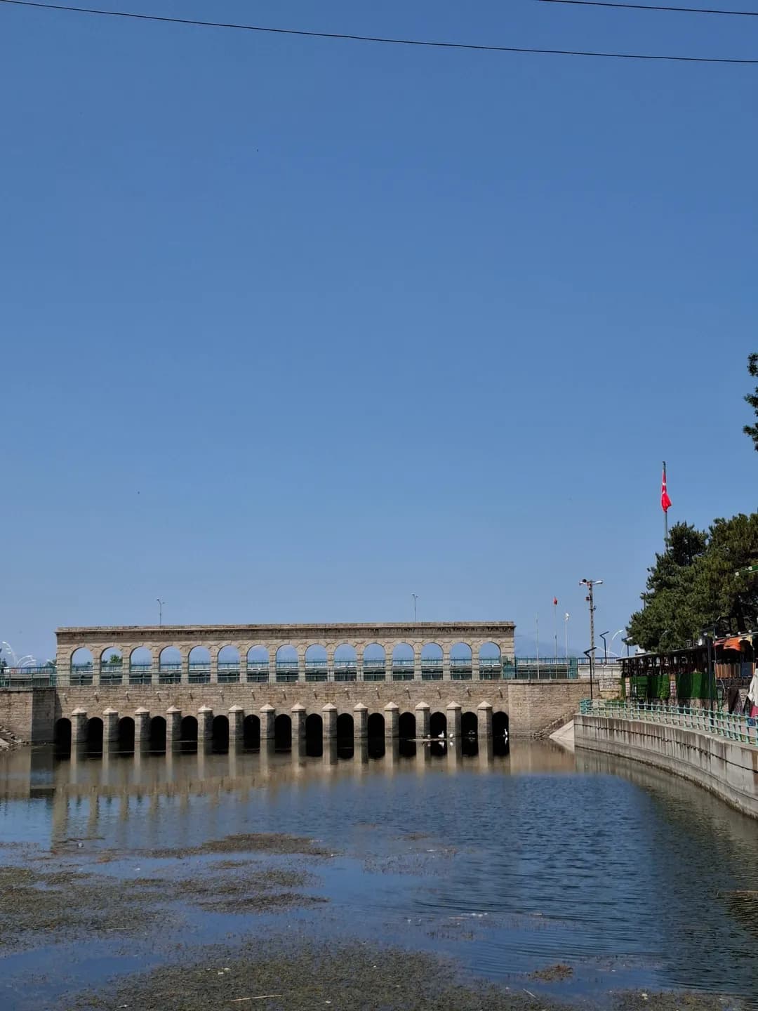
Beyşehir’s waterfront is more than the edge of a lake. It is also the point where water leaves the lake, where people have crossed between parts of town, and where a major irrigation project made a regional ambition visible in stone and iron. The Taş Köprü, or Stone Bridge, is the clearest landmark in that story. Its appearance invites a photograph, but its position at the outlet explains why this particular place mattered to engineers, farmers and town residents.
Start by distinguishing the broad lake surface from the narrower watercourse through town. Historical sources call the outlet Beyşehir Çayı; later works changed it into a regulated channel. The view links several scales at once: a pedestrian crossing, nearby neighbourhoods, the surrounding lake basin and agricultural land farther away. Water passing through the town was therefore never only a decorative feature. It connected local movement and livelihoods with decisions taken well beyond the waterfront.
The older town was organised around İçerişehir, the settlement within the fortifications beside the lake. Eşrefoğlu Mosque anchors this historic nucleus, where religious, commercial and domestic buildings occupied a compact setting. Outside the walls, records identify neighbourhoods including Hacı Armağan, Evsât and Dalyan along the watercourse. The terms İçerişehir and Dışarışehir preserve that distinction between the inner town and its outer settlement, even though later urban growth made the relationship more complex.
The old town should not be imagined as one building campaign frozen in time. Gates, prayer buildings, the bedesten, houses and the bathhouse served different needs and underwent changes. Population studies show that neighbourhood names and administrative groupings also shifted. Walking from the mosque towards the water thus crosses several historical layers: a fortified nucleus, streets of exchange and residence, and an outlet that became a focus of early twentieth-century infrastructure.
The present regulator replaced an earlier bridge during the Konya Plain irrigation project of 1908–1914. Hüseyin Muşmal’s study follows the negotiations, construction and wider water-management scheme. The undertaking involved the Ottoman administration and the Anatolian–Ottoman Railway Company; it was designed to convey and control water for agriculture. Its historical date matters. The stonework may look comfortably at home beside medieval heritage, but the regulator belongs to a much later engineering programme.
Fourteen masonry piers divide the structure into fifteen openings, with movable gates forming part of the regulating arrangement. This repeated rhythm is both architectural and functional: supports carry the crossing above, while openings organise the passage of water below. The municipal description and the historical study give slightly different overall lengths, around 41–42 metres. The important point for a visitor is the combined role of bridge and regulator, rather than an impression of precision based on one rounded measurement.
A project intended to improve irrigation also created disagreements about how water should move through a connected basin. Lake shores, channels and fields did not respond independently. Work that restricted flow at one point could affect communities elsewhere, especially during wet seasons. The regulator belongs within that larger system, and its history is easier to understand when the bridge is read alongside the changing channel and the agricultural ambitions of the Konya Plain.
Muşmal’s archival study of the major floods of 1910 and 1911 describes the interaction of high water and obstructions introduced during irrigation construction. The floods damaged lakeside settlements and agricultural land; correspondence carried local complaints and requests for action to provincial and central authorities. This was not simply a smooth story of technical progress. The same project brought promises of productive land and disputes over whose fields, homes and livelihoods would bear the consequences of altered flows.
Water also influenced where new residents could settle. Research on Chechen and Ingush migrants describes accommodation near the channel and health difficulties before the establishment of Hamidiye on higher ground in the early 1900s. House construction, land provision and subsequent arrivals expanded the town beyond its older core. That history belongs beside the monumental view: a waterfront is shaped not only by bridges and embankments but also by decisions about where families can live and work.
Historical population figures require their own geography. Barış Taş and İlker Yiğit show how district boundaries, neighbourhood groupings and surviving registers affect comparisons over time. Some nineteenth-century neighbourhood records are missing; an apparent fall in a table does not automatically demonstrate an abandoned town. Their research instead reveals an urban centre embedded in a much larger rural district, connected with surrounding villages through administration, trade and agriculture.
On the waterfront, compare the bridge’s repeated openings with the streets and open spaces leading towards it. Then return to the old-town buildings: the scale of the mosque portal, the enclosed market and the modest entrances of houses serve different purposes from a crossing and a water-control structure. The virtual model can help explain these relationships, but its interpreted details should not be mistaken for a measured record of every historic building or an exact reconstruction of an earlier shoreline.
For a walk, use current signed pedestrian spaces and the route’s practical notes; historical descriptions do not establish today’s crossing arrangements or accessibility. Continue to the mosque and bedesten for the inner town, read Hamidiye’s migration story for later urban growth, and follow the Mada Island article for another relationship between settlement and water. Seen together, these places make the waterfront a useful starting point for the city’s social history as well as its engineering history.
Water and City: Beyşehir’s Waterfront History
Explore the walled town, channel-side neighbourhoods and the 1908–1914 irrigation project that changed Beyşehir’s relationship with water.
Beyşehir’s waterfront is more than the edge of a lake. It is also the point where water leaves the lake, where people have crossed between parts of town, and where a major irrigation project made a regional ambition visible in stone and iron. The Taş Köprü, or Stone Bridge, is the clearest landmark in that story. Its appearance invites a photograph, but its position at the outlet explains why this particular place mattered to engineers, farmers and town residents.
Start by distinguishing the broad lake surface from the narrower watercourse through town. Historical sources call the outlet Beyşehir Çayı; later works changed it into a regulated channel. The view links several scales at once: a pedestrian crossing, nearby neighbourhoods, the surrounding lake basin and agricultural land farther away. Water passing through the town was therefore never only a decorative feature. It connected local movement and livelihoods with decisions taken well beyond the waterfront.
The older town was organised around İçerişehir, the settlement within the fortifications beside the lake. Eşrefoğlu Mosque anchors this historic nucleus, where religious, commercial and domestic buildings occupied a compact setting. Outside the walls, records identify neighbourhoods including Hacı Armağan, Evsât and Dalyan along the watercourse. The terms İçerişehir and Dışarışehir preserve that distinction between the inner town and its outer settlement, even though later urban growth made the relationship more complex.
The old town should not be imagined as one building campaign frozen in time. Gates, prayer buildings, the bedesten, houses and the bathhouse served different needs and underwent changes. Population studies show that neighbourhood names and administrative groupings also shifted. Walking from the mosque towards the water thus crosses several historical layers: a fortified nucleus, streets of exchange and residence, and an outlet that became a focus of early twentieth-century infrastructure.
The present regulator replaced an earlier bridge during the Konya Plain irrigation project of 1908–1914. Hüseyin Muşmal’s study follows the negotiations, construction and wider water-management scheme. The undertaking involved the Ottoman administration and the Anatolian–Ottoman Railway Company; it was designed to convey and control water for agriculture. Its historical date matters. The stonework may look comfortably at home beside medieval heritage, but the regulator belongs to a much later engineering programme.
Fourteen masonry piers divide the structure into fifteen openings, with movable gates forming part of the regulating arrangement. This repeated rhythm is both architectural and functional: supports carry the crossing above, while openings organise the passage of water below. The municipal description and the historical study give slightly different overall lengths, around 41–42 metres. The important point for a visitor is the combined role of bridge and regulator, rather than an impression of precision based on one rounded measurement.
A project intended to improve irrigation also created disagreements about how water should move through a connected basin. Lake shores, channels and fields did not respond independently. Work that restricted flow at one point could affect communities elsewhere, especially during wet seasons. The regulator belongs within that larger system, and its history is easier to understand when the bridge is read alongside the changing channel and the agricultural ambitions of the Konya Plain.
Muşmal’s archival study of the major floods of 1910 and 1911 describes the interaction of high water and obstructions introduced during irrigation construction. The floods damaged lakeside settlements and agricultural land; correspondence carried local complaints and requests for action to provincial and central authorities. This was not simply a smooth story of technical progress. The same project brought promises of productive land and disputes over whose fields, homes and livelihoods would bear the consequences of altered flows.
Water also influenced where new residents could settle. Research on Chechen and Ingush migrants describes accommodation near the channel and health difficulties before the establishment of Hamidiye on higher ground in the early 1900s. House construction, land provision and subsequent arrivals expanded the town beyond its older core. That history belongs beside the monumental view: a waterfront is shaped not only by bridges and embankments but also by decisions about where families can live and work.
Historical population figures require their own geography. Barış Taş and İlker Yiğit show how district boundaries, neighbourhood groupings and surviving registers affect comparisons over time. Some nineteenth-century neighbourhood records are missing; an apparent fall in a table does not automatically demonstrate an abandoned town. Their research instead reveals an urban centre embedded in a much larger rural district, connected with surrounding villages through administration, trade and agriculture.
On the waterfront, compare the bridge’s repeated openings with the streets and open spaces leading towards it. Then return to the old-town buildings: the scale of the mosque portal, the enclosed market and the modest entrances of houses serve different purposes from a crossing and a water-control structure. The virtual model can help explain these relationships, but its interpreted details should not be mistaken for a measured record of every historic building or an exact reconstruction of an earlier shoreline.
For a walk, use current signed pedestrian spaces and the route’s practical notes; historical descriptions do not establish today’s crossing arrangements or accessibility. Continue to the mosque and bedesten for the inner town, read Hamidiye’s migration story for later urban growth, and follow the Mada Island article for another relationship between settlement and water. Seen together, these places make the waterfront a useful starting point for the city’s social history as well as its engineering history.
Historic Bada Bridge & Irrigation Channels
A 14th-century caravan crossing expanded during the 1910 Konya Plain Irrigation project.
Bada Bridge belongs to a countryside journey, separate from the familiar waterfront crossing in central Beyşehir. GoKonya approaches it via the road towards Seydişehir and the turn towards Fasıllar. This geographical distinction matters: a picture or measurement of Taş Köprü cannot be transferred to Bada because both are historic stone bridges.
The name Alman Köprüsü, German Bridge, reflects its description in local tourism writing. GoKonya identifies the place on the countryside approach towards Fasıllar. Read that setting through the road, the channel and the fields beside the crossing. Start with a wider view before looking at individual stones: the approaches explain how the bridge belongs to the surrounding landscape.
Muşmal’s detailed study concerns the town-centre regulator and the early twentieth-century irrigation works. It provides wider context for regional water infrastructure, not a substitute engineering record for Bada. Together, the two crossings suggest how roads and water management shaped journeys around Beyşehir. The urban regulator and the rural bridge each belong to that wider landscape, with their own construction history.
From an authorised public position, consider the crossing in relation to channel, fields and approach roads. Record the place name and viewpoint with your photographs, then compare a broad landscape view with a closer look at the masonry. Ask locally about access and follow the public approach. The countryside setting gives this stop its own character within a wider journey around Beyşehir.
A rural crossing can be read through its approaches. Look at where a road or track meets the structure, how the channel occupies the ground and how the surrounding fields shape the view. These relationships give the bridge a local setting even when a detailed construction history is not yet available.
Take a view that includes both bank and crossing before concentrating on stonework. An isolated arch could be difficult to identify later, especially after visiting the town-centre bridge on the same trip. A short caption with the place name and viewpoint keeps the photographs useful.
Compare the experience with Taş Köprü without making the buildings identical. One encounter belongs to an urban waterfront and the regulator story; the other introduces the countryside and its approaches. The change of setting is itself worth recording, alongside whatever architectural details can be seen from permitted ground.
Artisans of Huğlu and Üzümlü offers another account of the working region beyond the lakefront, while Reading stone leads towards the archaeological landscape. Use these thematic links to choose separate visits, checking the real travel arrangements rather than assuming that related stories form one continuous walking route.
The WWII Beyşehir Internment Camp
The story of German naval personnel interned in Beyşehir during 1944–1945.
Beyşehir’s twentieth-century history includes compulsory residence far removed from a normal lakeside visit. Hüseyin Muşmal and Hasret Gümüş examine German naval personnel held in the town during the closing phase of the Second World War. Their research draws on memoirs, diaries and accounts from people connected with the events.
Identify the subject precisely: approximately 320 German naval servicemen, not an undifferentiated group of civilians and soldiers. The wider September 1944–July 1946 chronology spans different locations and circumstances. The study distinguishes roughly eight months in Beyşehir from the later period in Isparta. The whole interval must not be described as time spent in Beyşehir.
Events in the Black Sea and Turkey’s changing wartime position provide context. Internment is not a voluntary holiday, even when memoirs describe ordinary activities or encounters with residents. Administrative status, restrictions and transfer are part of the history. A diary conveys its author’s perspective; a later interview may remember the period differently. Neither justifies claiming everybody had the same experience.
The historical town image supplies urban context, not a photograph of internees or the camp. No present-day building is identified as a visitable camp site without further evidence. Reading this chapter alongside familiar monuments shows how international conflict entered local history, while preserving the documented relationship between people, dates and places instead of turning a difficult episode into a picturesque anecdote.
A memoir often makes an unfamiliar period readable through ordinary details. Meals, daily routines or contact with residents can draw a reader close to one person's experience. Keep those details alongside the administrative circumstances that shaped the stay; familiarity in the writing does not remove compulsion.
Build a simple timeline while reading the study. Mark the Beyşehir period separately from the later Isparta period, and distinguish a remembered event from the date an account was written. This helps avoid stretching a short local episode across the whole wartime and post-war chronology.
Compare the kinds of evidence used by the researchers. A diary written during events, a later memoir and an interview can illuminate different aspects of the past. Agreement can be informative, but differences should not automatically be smoothed away into one seamless narrative.
Travelers' accounts offers a useful contrast in why outsiders came to the town and how they described it. Reading the two together expands the history beyond monuments while keeping voluntary travel and internment distinct. The present lake view can provide a setting for reflection without being labelled as a documented camp viewpoint.
Related places