
Reference overview
XX. Yüzyılın Başlarında Beyşehir Gölü ve 1910–1911 Yılları Büyük Taşkın Hadiseleri
Hüseyin Muşmal · Selçuk Üniversitesi Türkiyat Araştırmaları Dergisi
Read the place guides and stories that draw on this source.
Read with your device’s voice.
Taş Köprü
A work of water engineering and a familiar city landmark.
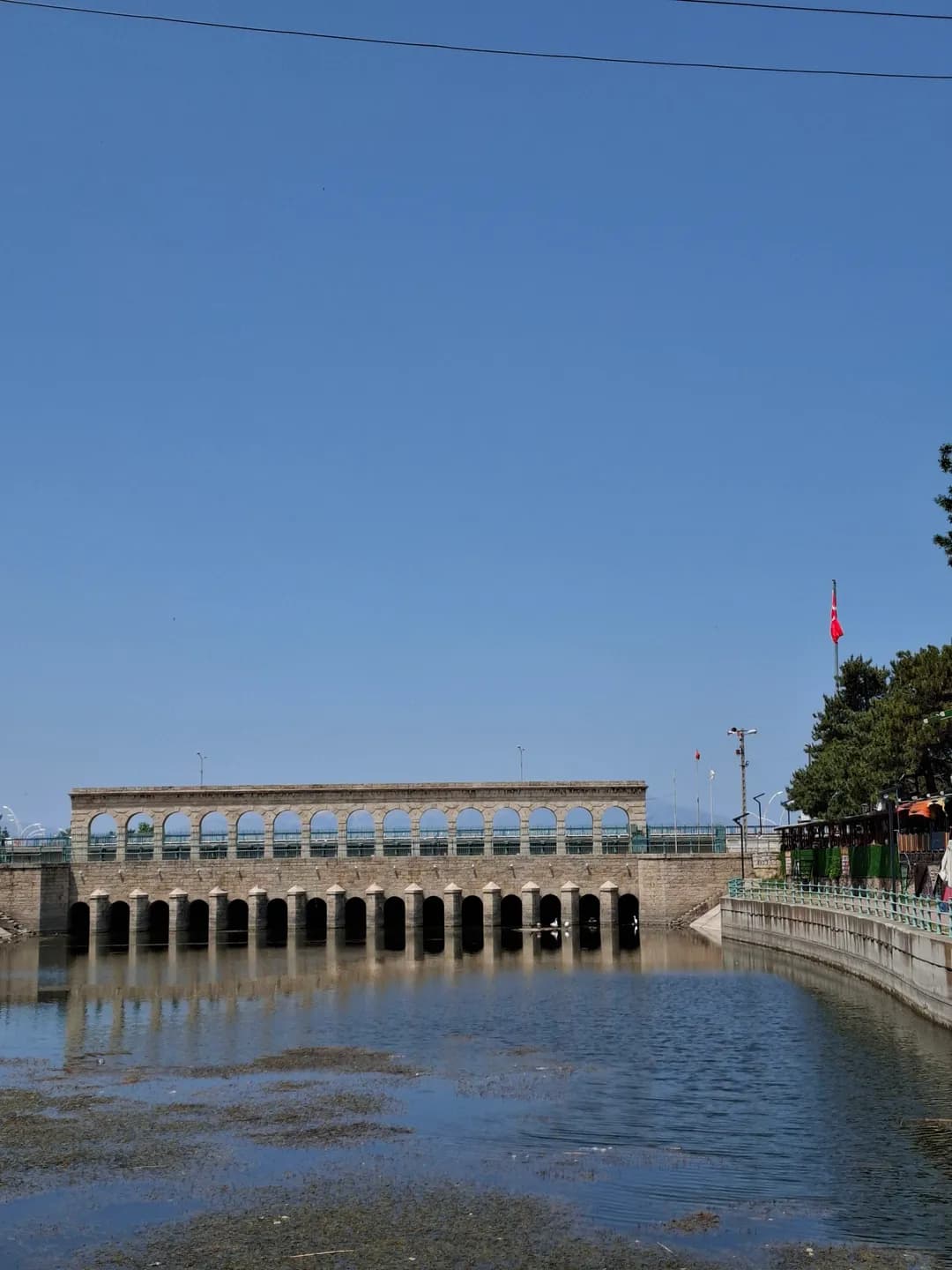
Beyşehir’s waterfront is more than the edge of a lake. It is also the point where water leaves the lake, where people have crossed between parts of town, and where a major irrigation project made a regional ambition visible in stone and iron. The Taş Köprü, or Stone Bridge, is the clearest landmark in that story. Its appearance invites a photograph, but its position at the outlet explains why this particular place mattered to engineers, farmers and town residents.
Start by distinguishing the broad lake surface from the narrower watercourse through town. Historical sources call the outlet Beyşehir Çayı; later works changed it into a regulated channel. The view links several scales at once: a pedestrian crossing, nearby neighbourhoods, the surrounding lake basin and agricultural land farther away. Water passing through the town was therefore never only a decorative feature. It connected local movement and livelihoods with decisions taken well beyond the waterfront.
The older town was organised around İçerişehir, the settlement within the fortifications beside the lake. Eşrefoğlu Mosque anchors this historic nucleus, where religious, commercial and domestic buildings occupied a compact setting. Outside the walls, records identify neighbourhoods including Hacı Armağan, Evsât and Dalyan along the watercourse. The terms İçerişehir and Dışarışehir preserve that distinction between the inner town and its outer settlement, even though later urban growth made the relationship more complex.
The old town should not be imagined as one building campaign frozen in time. Gates, prayer buildings, the bedesten, houses and the bathhouse served different needs and underwent changes. Population studies show that neighbourhood names and administrative groupings also shifted. Walking from the mosque towards the water thus crosses several historical layers: a fortified nucleus, streets of exchange and residence, and an outlet that became a focus of early twentieth-century infrastructure.
The present regulator replaced an earlier bridge during the Konya Plain irrigation project of 1908–1914. Hüseyin Muşmal’s study follows the negotiations, construction and wider water-management scheme. The undertaking involved the Ottoman administration and the Anatolian–Ottoman Railway Company; it was designed to convey and control water for agriculture. Its historical date matters. The stonework may look comfortably at home beside medieval heritage, but the regulator belongs to a much later engineering programme.
Fourteen masonry piers divide the structure into fifteen openings, with movable gates forming part of the regulating arrangement. This repeated rhythm is both architectural and functional: supports carry the crossing above, while openings organise the passage of water below. The municipal description and the historical study give slightly different overall lengths, around 41–42 metres. The important point for a visitor is the combined role of bridge and regulator, rather than an impression of precision based on one rounded measurement.
A project intended to improve irrigation also created disagreements about how water should move through a connected basin. Lake shores, channels and fields did not respond independently. Work that restricted flow at one point could affect communities elsewhere, especially during wet seasons. The regulator belongs within that larger system, and its history is easier to understand when the bridge is read alongside the changing channel and the agricultural ambitions of the Konya Plain.
Muşmal’s archival study of the major floods of 1910 and 1911 describes the interaction of high water and obstructions introduced during irrigation construction. The floods damaged lakeside settlements and agricultural land; correspondence carried local complaints and requests for action to provincial and central authorities. This was not simply a smooth story of technical progress. The same project brought promises of productive land and disputes over whose fields, homes and livelihoods would bear the consequences of altered flows.
Water also influenced where new residents could settle. Research on Chechen and Ingush migrants describes accommodation near the channel and health difficulties before the establishment of Hamidiye on higher ground in the early 1900s. House construction, land provision and subsequent arrivals expanded the town beyond its older core. That history belongs beside the monumental view: a waterfront is shaped not only by bridges and embankments but also by decisions about where families can live and work.
Historical population figures require their own geography. Barış Taş and İlker Yiğit show how district boundaries, neighbourhood groupings and surviving registers affect comparisons over time. Some nineteenth-century neighbourhood records are missing; an apparent fall in a table does not automatically demonstrate an abandoned town. Their research instead reveals an urban centre embedded in a much larger rural district, connected with surrounding villages through administration, trade and agriculture.
On the waterfront, compare the bridge’s repeated openings with the streets and open spaces leading towards it. Then return to the old-town buildings: the scale of the mosque portal, the enclosed market and the modest entrances of houses serve different purposes from a crossing and a water-control structure. The virtual model can help explain these relationships, but its interpreted details should not be mistaken for a measured record of every historic building or an exact reconstruction of an earlier shoreline.
For a walk, use current signed pedestrian spaces and the route’s practical notes; historical descriptions do not establish today’s crossing arrangements or accessibility. Continue to the mosque and bedesten for the inner town, read Hamidiye’s migration story for later urban growth, and follow the Mada Island article for another relationship between settlement and water. Seen together, these places make the waterfront a useful starting point for the city’s social history as well as its engineering history.
Water and City: Beyşehir’s Waterfront History
Explore the walled town, channel-side neighbourhoods and the 1908–1914 irrigation project that changed Beyşehir’s relationship with water.
Beyşehir’s waterfront is more than the edge of a lake. It is also the point where water leaves the lake, where people have crossed between parts of town, and where a major irrigation project made a regional ambition visible in stone and iron. The Taş Köprü, or Stone Bridge, is the clearest landmark in that story. Its appearance invites a photograph, but its position at the outlet explains why this particular place mattered to engineers, farmers and town residents.
Start by distinguishing the broad lake surface from the narrower watercourse through town. Historical sources call the outlet Beyşehir Çayı; later works changed it into a regulated channel. The view links several scales at once: a pedestrian crossing, nearby neighbourhoods, the surrounding lake basin and agricultural land farther away. Water passing through the town was therefore never only a decorative feature. It connected local movement and livelihoods with decisions taken well beyond the waterfront.
The older town was organised around İçerişehir, the settlement within the fortifications beside the lake. Eşrefoğlu Mosque anchors this historic nucleus, where religious, commercial and domestic buildings occupied a compact setting. Outside the walls, records identify neighbourhoods including Hacı Armağan, Evsât and Dalyan along the watercourse. The terms İçerişehir and Dışarışehir preserve that distinction between the inner town and its outer settlement, even though later urban growth made the relationship more complex.
The old town should not be imagined as one building campaign frozen in time. Gates, prayer buildings, the bedesten, houses and the bathhouse served different needs and underwent changes. Population studies show that neighbourhood names and administrative groupings also shifted. Walking from the mosque towards the water thus crosses several historical layers: a fortified nucleus, streets of exchange and residence, and an outlet that became a focus of early twentieth-century infrastructure.
The present regulator replaced an earlier bridge during the Konya Plain irrigation project of 1908–1914. Hüseyin Muşmal’s study follows the negotiations, construction and wider water-management scheme. The undertaking involved the Ottoman administration and the Anatolian–Ottoman Railway Company; it was designed to convey and control water for agriculture. Its historical date matters. The stonework may look comfortably at home beside medieval heritage, but the regulator belongs to a much later engineering programme.
Fourteen masonry piers divide the structure into fifteen openings, with movable gates forming part of the regulating arrangement. This repeated rhythm is both architectural and functional: supports carry the crossing above, while openings organise the passage of water below. The municipal description and the historical study give slightly different overall lengths, around 41–42 metres. The important point for a visitor is the combined role of bridge and regulator, rather than an impression of precision based on one rounded measurement.
A project intended to improve irrigation also created disagreements about how water should move through a connected basin. Lake shores, channels and fields did not respond independently. Work that restricted flow at one point could affect communities elsewhere, especially during wet seasons. The regulator belongs within that larger system, and its history is easier to understand when the bridge is read alongside the changing channel and the agricultural ambitions of the Konya Plain.
Muşmal’s archival study of the major floods of 1910 and 1911 describes the interaction of high water and obstructions introduced during irrigation construction. The floods damaged lakeside settlements and agricultural land; correspondence carried local complaints and requests for action to provincial and central authorities. This was not simply a smooth story of technical progress. The same project brought promises of productive land and disputes over whose fields, homes and livelihoods would bear the consequences of altered flows.
Water also influenced where new residents could settle. Research on Chechen and Ingush migrants describes accommodation near the channel and health difficulties before the establishment of Hamidiye on higher ground in the early 1900s. House construction, land provision and subsequent arrivals expanded the town beyond its older core. That history belongs beside the monumental view: a waterfront is shaped not only by bridges and embankments but also by decisions about where families can live and work.
Historical population figures require their own geography. Barış Taş and İlker Yiğit show how district boundaries, neighbourhood groupings and surviving registers affect comparisons over time. Some nineteenth-century neighbourhood records are missing; an apparent fall in a table does not automatically demonstrate an abandoned town. Their research instead reveals an urban centre embedded in a much larger rural district, connected with surrounding villages through administration, trade and agriculture.
On the waterfront, compare the bridge’s repeated openings with the streets and open spaces leading towards it. Then return to the old-town buildings: the scale of the mosque portal, the enclosed market and the modest entrances of houses serve different purposes from a crossing and a water-control structure. The virtual model can help explain these relationships, but its interpreted details should not be mistaken for a measured record of every historic building or an exact reconstruction of an earlier shoreline.
For a walk, use current signed pedestrian spaces and the route’s practical notes; historical descriptions do not establish today’s crossing arrangements or accessibility. Continue to the mosque and bedesten for the inner town, read Hamidiye’s migration story for later urban growth, and follow the Mada Island article for another relationship between settlement and water. Seen together, these places make the waterfront a useful starting point for the city’s social history as well as its engineering history.
Related places
2008, 23 219–262